It is called Fort Jesus in Portuguese and Spanish, respectively. It is located on the island of Mombasa and is a fortification dating back to the 16th century. It was built between 1593 and 1596 on the orders of King Filipe I of Portugal, who also reigned as King Felipe II of Castille and the Algarves, to secure the Old Port of Mombasa. The Italian architect Giovanni Battista Cairati designed it to be constructed between 1593 and 1596. Ft. Jesus was the sole Portuguese fortification on the Swahili Coast. It is widely regarded as the site of the first successful attempt by a Western nation to gain influence over the Indian Ocean trade.
Cairato, the fort’s designer, was influenced by Italian architect Pietro Cataneo, while Gaspar Rodrigues was in charge of the construction. The fort was Cairato’s final international assignment. Even though the design of Fort Jesus is a fine example of Renaissance architecture, it is thought that the masonry techniques, building supplies, and labor were all provided by the local Swahili people who lived nearby. The fort was constructed in the figure of a man (as seen from above) and is roughly square, with four bulwarks at each of its four corners. The fort is regarded as a masterpiece of the late Renaissance period in military fortification.
Between 1631, when the Portuguese lost it to the Sultan Yusuf ibn al-Hasan of Mombasa, and 1895, when it came under British control and was transformed into a jail, Fort Jesus was taken and recaptured at least nine times, according to historical records. Following the Portuguese recovery of the fort from the Sultan in 1632, they renovated it. They added extra fortifications, making it more difficult to fall. From 1696 to 1698, the fort was subjected to an epic two-year siege by the Omani Arabs, led by Saif bin Sultan, who managed to capture the fort. Although they briefly caught and reoccupied the fort between 1728 and 1729 with the assistance of the Swahili city-states, the capture of the fort signaled the end of Portuguese presence on the African coast. The fort was under local control from 1741 to 1837, when it was retaken by the Omanis and used as a barracks until it was re-acquired by the British in 1895, following the foundation of the East Africa Protectorate, and used as a military base that later in 1920 became Kenya’s Colony and Protectorate.
After being designated a national park in 1958, Fort Jesus was appointed a World Heritage Site by the United Nations Educational, Scientific, and Cultural Organization (UNESCO) in 2011. It is considered one of the most outstanding and well-preserved examples of 16th-century Portuguese military fortifications.
Mombasa’s fort is the most popular tourist destination in the city.
In the period 1631-1875, the fort was captured and retaken nine times by the various powers vying for the sovereignty of Kenya. The Omanis captured the fort in 1698 following a long and bloody siege that lasted nearly three years. 1958 marked the year that it was designated as a historical landmark. It is being used as a museum.
Italian architect Giovanni Battista Cairati, who worked as the Chief Architect for Portuguese territories in the East, constructed the fortifications at Forte Dei Marmi. It was the first European-style fortification built outside of Europe designed to withstand cannon fire, making it a historical landmark. This structure, which has been influenced and changed by both the Omani Arabs and the British, is one of the great architectural examples of 16th-century Portuguese military architecture. Within a short period, the fort had become a necessary property for anyone wishing to exert authority over Mombasa Island or the adjacent trading areas. When the British annexed Kenya, they utilized the building as a prison until 1958. It was converted into a historical monument to commemorate colonization. James Kirkman was subsequently tasked with excavating the memorial, which he accomplished from 1958 to 1971 (with significant assistance from external historical materials).
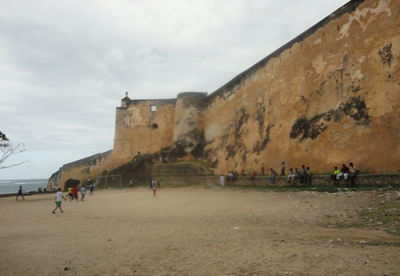
The fort’s architecture is based on a rough outline of a person lying on their back with their head pointing towards the sea, as seen from above. The walls rise to a total height of 18 meters. The Portuguese fort had a height of 15 meters. Still, the Oman Arabs increased the size of the fort by 3 meters after taking it.
The fort has aspects from Portugal, the Arab world, and the United Kingdom (the significant powers that held it during different times in history). The existence of Portuguese and British guns ensures that the presence of the two countries is retained. Although the Portuguese cannons only had a range of 200 meters, they were significantly longer than the cannons by the British, which had a range of 300 meters. Arabs from Oman left several inscriptions from the Koran on wooden doorposts and ceiling beams, indicating their presence in the building. The Muslim tradition of five pillars is also depicted throughout the fort. A previous meeting hall is supported by five stone pillars that reach the ceiling from the floor to the top.
In the fort, specific historical structures are still intact, such as Oman House, which served as the residence of the Sultan, who ruled over the East African coast for many years. Other notable structures include an open water cistern built by the Portuguese to collect rainwater and a 76-foot-deep well dug by the Arabs (its water was too salty to be used for anything but washing).
In the year 2011, the United Nations Educational, Scientific, and Cultural Organization (UNESCO) designated the fort as a World Heritage Site.